Elevations thanks to Matthew Neeley and Matlab
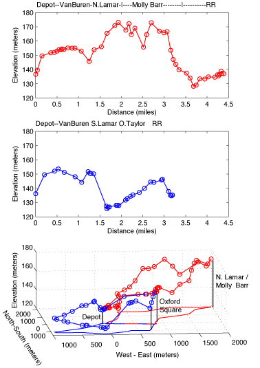
The interactive map below can be zoomed and panned with the controls or dragged with your mouse. The map markers also have info windows. At high magnification, in hybrid mode, you will notice that the satellite imagery and the street images don't quite align. The 2D elevation profiles both begin at the Depot and head toward the square.
Constructed using the Google Maps API and Jon's Map Tracer Utility.
The North Lamar Loop (counter clockwise) starts at the Depot, follows Van Buren to the Square and climbs to a high point at the intersection of N. Lamar and Molly Bar. Bike paths on both sides of Molly Barr The path as drawn follows the rail bed (still gravel but rideable) south to Jackson Ave. An alternative for the present is to continue on Molly Barr to the Gertrude Ford Parkway (recent extension not on the google map) and back to the Depot.
The South Lamar Loop (clockwise) begins the same, a right turn on S. Lamar leads to Old Taylor Road and past Rowan Oak. The pathway as plotted crosses Taylor Road and enters the MDOT parking lot, a gravel walkway at the far end of the lot connects to the original railbed. This route takes you past the south entrance to the football stadium and back to Gertrude Ford Parkway. An alternative for the present is to go North on Taylor road and around the roundabout to Gertrude Ford Parkway and back to the Depot.
Questions:
North LoopAnother nice example of google maps is USA running maps at http://www.walkjogrun.net/. This site uses google maps to allow you to lay out running routes with mileage and projected times.