Oxford/University Pathways Project
Google Biking directions from The Lyceum to City Hall .
Also a tool to visualize hills along the route.
Tues, Mar. 6 2007 Pathways info is in transition to a new site
I will keep this page up as an archive for a while. Please look for
current meeting agendas and updates at www.loupathways.org.
Jan. 22 2007 Memo (PDF) on University Pathways Opportunities
Wednesday, Sept. 13 2006 LOUPathways Meeting Summary
- Bids for construction of phase 1 (Railway Conversion - McElroy Drive) Low Bid from Mike Bennet was accepted Tues 9/12!!!! A few weeks for MDOT and Federal? approval and 120 "working" days and we should have a Rail/trail.
- Summary of TEA Proposal to MDOT for Phase 2 - Submitted July 31 2006
- 1. Completion the Core loop:Molly Barr - N. Lamar Douglas/Williams - Bramlett - S. 18th -Access/Frontage Rds to Old Taylor.
- 2. "Pocket park" between Jackson and City Pool, kid's off-road path through the woods.
- 3. Bike lanes South on College Hill to Jackson Ave.
- 4. Sisk Avenue from Bramlett to Conference Ctr.
- 5. S 18th to Belk Dr and on Belk Dr from Hwy 7 to S. Lamar.
See the interactive map of the Proposed Oxford Pathways Network
Tim Akers says no word yet, MDOT has 80 proposals
- Report on University Meeting with Vice Chancellor Kellum. (Memo - PDF) University is on board in principal. Will invite Ian Banner, Director of Facilities Planning to next meeting
- Discuss Unified Signage, discussed Maps on Pathway signs.
- Hwy 314 From city limits to Toby Tuby Creek (4.5 miles) will transferred to city/county control from MDOT. MDOT will add bike lanes with next resurfacing. Time frame uncertain, likely years rather than months. City Athletic Fields, will be constructed on 314 ~ 3 miles from town (just before the hills). Discussed the possibility of including a BMX course or Bike trails
- Safe Routes to School (SRTS) Program - Deadline Dec. 1, 2006. MDOT has $1million/yr for 5 yrs, to promote walking and biking to school to promote wellness and alleviate traffic and congestion. More info at http://www.saferoutesinfo.org/
Subsequent Activity - UM professors Greg Easson (Traffic), Mark Loftin(Childhood Obesity), Jeff Hallam (Healthy Lifestyles), Matt Zuefle(Parks and Rec) have signed on to help with the proposal, Patrick Gunnin of the Boys and Girls Club is also on board. The Oxford School board will discuss the proposal at its next meeting Monday Sept 25. Here is an interactive map with Oxford Schools Marked, Circles are at half mile increments from CES, 10 minutes at a brisk walk. - MDWFP Recreational Trails Program $10-100k 20% match required. More info at: Deadline October 31, 2006. 2 options were discussed -
- 1. a short accessible trail in town, through the wooded area adjacent to the railway between the city swimming pool and Jackson Ave.
- 2. The BMX course on 314.
- Subsequent Activity - Presented preliminary plans to Oxford Park Commission Board Sep 20. Contacted Jeff Williams to discuss the athletic complex site layout. Brad Cannon, Kate Kellum, Kevin Stuart and Matt Zuefle are collaborating.
- Set agenda for Next Mtg, 10/11/2006 (2nd Wed of Oct). Three priorities
- 1. Come to a decision on the Rec. Trails proposal. Get a group together - Park commission, Oxford Bike Club Trail builders, Kevin Stuart (BMX expertise), Jeff Williams (Engineer for Athletic complex), Mike Mossing, Tim Akers
- 2. Initiate work on SRTS proposal Convene a working group - Parents, District Officials, Traffic and Wellness experts from UM Hold a public Meeting Present initial plans, accept community input
- 3. Plan Opening ceremonies for the Railway Conversion.
Wednesday, June 7, 2006. Pathway Phase 1 approved by MDOT and Board of Alderman and advertized.
- Phase 1 - Final Components as submitted for bids 6/7/2006
- Add Bike Lanes on McElroy Dr
- Pave Railbed from Molly Barr to Jackson Ave
- Pedestrian Bridge over Jackson
- Connections through the Depot to Bike lanes on G. Ford Pkwy
- Bike Lanes on University Place
- (Bike/Walk lanes added to Old Taylor Bridge @ Hwy 6 to be completed in a separate already-funded project, now in design phase)
- Bike Lanes on either side of Old Taylor from Hwy 6 to Whirlpool Light
- 2-way bike path on west side of Old Taylor from Whirlpool light to TVA Right of Way
- Gravel? Path to Old Railbed
- Replacement of Washed out Trestle with culverts, grade adjacent Railbed to meet 6% Guidelines
- Resurface Railbed with packed gravel
- Phase 1 - Projected Timeline
- Project Advertised June 7, 2006
- Bids Open July 12, 2006
- Work Begins on or around Aug 1, 2006
- Project Completed on or around Feb 1, 2007
Monday, Dec. 12, 2005. Meeting this morning with Mayor Howorth, Kevin Mcleod, Tim Akers, David Bennett, Carol Dorsey, Kate Kellum, Roger Franck. Easement issues are being worked on, with some delays that the city expects to have resolved in a matter of weeks. Barring a timely solution, will meet again to discuss options. Sharrows idea nixed by Mr. Bennett -- against federal/state highway codes. Plan to indicate preferred routes with maps and signs, coordinate signage with core pathway. If you want to suggest a route to be added to the core, you can use the Maptracer utility. Follow the instructions to make a polyline and paste the code into an email to me.
Monday, November 28, 2005. Another Google Map. A leg that connects N. Lamar to Park Dr. / Bramlett Blvd. / S. 18th and Access and Frontage Roads South of Hwy 6 to Old Taylor. Alternates to the N. and S. Lamar loops are also indicated. A few points of interest (Bike shops) are indicated.
Wednesday, November 23, 2005. Brief report from the Pathways committee meeting on Nov. 16. Mayor Howorth outlined an alternative route for the pathway that avoids disputed property. A proposal to designate core pathways was discussed. New Google maps of proposed bikeways have been posted, these are fully interactive, and include satellite imagery. Separate long term plans for a maps for a city-wide network and short term plans for loops that connect the Depot to North and South Lamar that include elevation profiles have been posted.
Wednesday, November 9, 2005. Land dispute with county holds up Pathways as reported by Lucy Schultze in the Oxford Eagle.
Monday, August 15, 2005. The city pathways project page has been updated along with a preliminary map of the project and tentative project dates. "Phase I of this project is to create the "backbone" portion: a continuous path from Molly Barr Road south to Thacker Mountain. ... Construction is slated to begin late 2005, or early 2006 with completion estimated for late 2006. More details will be added here as the project proceeds."
Wednesday, August 10, 2005.. President Bush signed the SAFETEA Highway bill that will fund the Oxford pathway project and up to $3 billion more in pathways across the country.
Friday, July 8, 2005. Engineers presented final plans for phase 1 of the Oxford pathways project. Plans to pave the Old railroad bed from Molly Barr road to Jackson Avenue and to refurbish the railbed with a soft surface from Highway 6 South to near Thacker Mountain are moving ahead.
The charge to the Pathways committee is to help develop a cohesive plan for biking in Oxford. Minutes of our last meeting noted many issues that remain to be addressed. Here is an idea for map that may be useful to focus our efforts. The map is based on a PDF file available from MDOT.
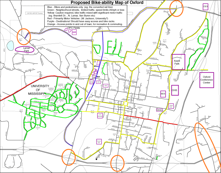
Link to bigger map. (256kb) | PDF file (2Mb)
Key elements of the plan should include:
- A core set of paths (blue and yellow) that link neighborhood streets (green) and key points of interest (purple) in town.
- Access points (Orange) in and out of town for commuting and recreation.
- An education and outreach component to promote safe use of the pathways.
- Others?
Pathways Notes
- Oxford Eagle Story Nov 9 2005
- Pathways Meeting Notes 8 September 05
- Oxford Pathways Project Plans
- Public Meeting Notes 18 April 05
- Oxford Eagle Story March 2005
Links
- City of Oxford
- Maps and Transportation Data
- Safe Routes to School
- Bike Advocacy